One of the key benefits of using platforms with AR is the ability to bypass traditional ‘coding’ and ‘translation’ models of spatial communication. Planning is based on communication between all people involved. As academics at the University of Kaiserslautern, Germany, point out in their paper 'Augmented Reality as a Communication Tool in Urban Design Processes’, the vocabulary used by planners is typically difficult to understand for lay people, who must decode messages laden with technical jargon, and interpret classical two-dimensional visualisations to understand their three-dimensional implications (refer below image). Tools that promise to simplify the communication process, and bring transparency to the spatial information presented by planners reduce the possibilities of ‘transmission errors’ between urban design professionals and citizens affected by the planning process. Augmented Reality can play a part in simplifying the communication of spatial information to the public.
Two Use Cases where Augmented Reality is used to communicate spatial proposals to city dwellers are the ‘Stadtmitte am Fluss’ project by the City of Saarbrucken, Germany; and the Christchurch Central Recovery Plan (CCRP), by Christchurch City Council, New Zealand. Both government bodies have developed apps that run on tablet-based devices to communicate their urban planning proposals to the public.
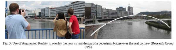
For the ‘Stadtmitte am Fluss’ project in Saarbrucken, the research team at the CPE department of the University of Kaiserslautern developed an 'urban walk' with AR overlays of new, proposed designs onto their real intended sites. 'Stations' were set up along a virtual tour, where users could stop and overlay virtual proposals and video, directly comment on, and rate the presented schemes. As well as helping to more intuitively present the future schemes to their intended audience, these apps enabled a more direct conversation between the public and the planners behind the proposals.
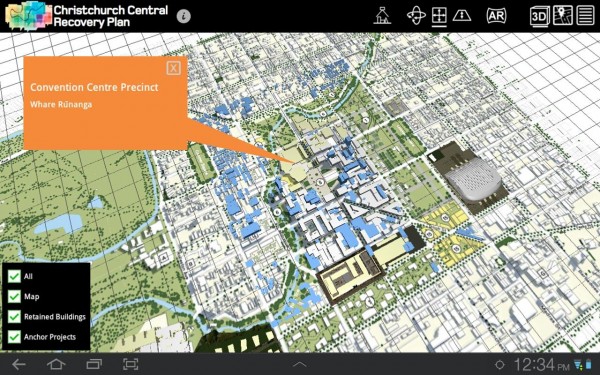
In a similar vein, the HITlab research team in Christchurch employed an interactive approach to showcase plans for Christchuch's urban future following the 2012 earthquake (see earlier post on this). The tablet-based app allowed users to walk around real Christchurch sites and 'see' augmented 3D models on site, to scale, and in real-time. Built into the platform was the ability for users to directly comment on the schemes, exploiting the opportunity presented by the technology to open up direct lines of communication between city residents and government planning bodies. In conjunction with geo-located, one-to-one scale AR model overlays, the HITlab team developed a tablet-based tool to augment printed plans of Christrchurch city with 3D AR models, and hyperlink to further information on the proposals. By pulling together a variety of communication media, the visual marker-based app simplified access to spatial information, and streamlined the communication of intended urban design developments to the public.